VAC chart of LF2465
 Satellite view of LF2465

Satellite view of LF2465
Sorry, we have no imagery here.
Sorry, we have no imagery here.
Sorry, we have no imagery here.
Sorry, we have no imagery here.
Sorry, we have no imagery here.
Sorry, we have no imagery here.


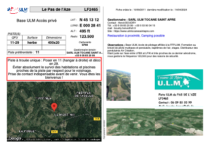
LF2465 - Le Pas de l'Aze
Located in Tocane-Saint-Apre, France
ICAO - , IATA -
Data provided by AirmateGeneral information
Coordinates: N45°13'12" E0°28'41"
Elevation is 495 feet MSL.
View others Airports in Aquitaine
Operational data
Special qualification required
Current time UTC: 07:37:45
Current local time:
Weather at : LFBX - Perigueux Bassillac ( 27 km )
METAR: LFBX 240730Z AUTO 00000KT 5000 BR OVC003 12/11 Q1022
Communications frequencies: [VIEW]
Runways:
| RWY identifier | QFU | Length (ft) | Width (ft) | Surface | LDA (ft) |
| 11 | 0° | 1312 | 65 | GRASS | |
| 29 | 0° | 1312 | 65 | GRASS |
Airport contact information
Address: Tocane-Saint-Apre France
Satellite view of LF2465
Sorry, we have no imagery here.
Sorry, we have no imagery here.
Sorry, we have no imagery here.
Sorry, we have no imagery here.
Sorry, we have no imagery here.
Sorry, we have no imagery here.