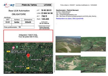
VAC chart of LF2458
 Satellite view of LF2458

Satellite view of LF2458
Sorry, we have no imagery here.
Sorry, we have no imagery here.
Sorry, we have no imagery here.
Sorry, we have no imagery here.
Sorry, we have no imagery here.
Sorry, we have no imagery here.


LF2458 - Piste du Tartou
Located in Tartou, France
ICAO - , IATA -
Data provided by AirmateGeneral information
Coordinates: N45°39'1" E0°34'30"
Elevation is 756 feet MSL.
View others Airports in Poitou-Charentes
Operational data
Special qualification required
Current time UTC: 16:53:35
Current local time:
Weather at : LFBU - Angouleme Brie Champniers ( 29 km )
METAR: LFBU 211630Z AUTO 25010KT 9999 BKN008/// BKN013/// OVC024/// ///TCU 15/14 Q1016 TEMPO 4000 -SHRA BKN010 BKN020TCU
TAF: TAF LFBU 211100Z 2112/2212 23010KT 9999 BKN030 TEMPO 2112/2120 4000 -SHRA BKN010 BKN020TCU BECMG 2120/2122 31005KT PROB40 TEMPO 2201/2206 3000 BR BECMG 2206/2208 36010KT BKN010 BECMG 2208/2210 BKN020 BECMG 2210/2212 CAVOK
Communications frequencies: [VIEW]
Runways:
| RWY identifier | QFU | Length (ft) | Width (ft) | Surface | LDA (ft) |
| 13 | 0° | 1082 | 65 | GRASS | |
| 31 | 0° | 1082 | 65 | GRASS |
Airport contact information
Address: Tartou France
Satellite view of LF2458
Sorry, we have no imagery here.
Sorry, we have no imagery here.
Sorry, we have no imagery here.
Sorry, we have no imagery here.
Sorry, we have no imagery here.
Sorry, we have no imagery here.