VAC chart of LF2449
 Satellite view of LF2449

Satellite view of LF2449
Sorry, we have no imagery here.
Sorry, we have no imagery here.
Sorry, we have no imagery here.
Sorry, we have no imagery here.
Sorry, we have no imagery here.
Sorry, we have no imagery here.


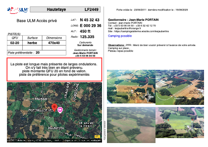
LF2449 - Hautefaye
Located in Hautefaye, France
ICAO - , IATA -
Data provided by AirmateGeneral information
Coordinates: N45°32'43" E0°29'36"
Elevation is 450 feet MSL.
View others Airports in Poitou-Charentes
Operational data
Special qualification required
Current time UTC: 06:21:13
Current local time:
Weather at : LFBU - Angouleme Brie Champniers ( 30 km )
METAR: LFBU 250600Z AUTO VRB02KT 9999 SCT022 SCT140 BKN170 13/12 Q1020 NOSIG
TAF: TAF LFBU 250500Z 2506/2606 22005KT 9999 BKN020 TEMPO 2514/2518 26015G25KT 4000 SHRA BKN020TCU
Communications frequencies: [VIEW]
Runways:
| RWY identifier | QFU | Length (ft) | Width (ft) | Surface | LDA (ft) |
| 02 | 0° | 1541 | 131 | GRASS | |
| 20 | 0° | 1541 | 131 | GRASS |
Airport contact information
Address: Hautefaye France
Satellite view of LF2449
Sorry, we have no imagery here.
Sorry, we have no imagery here.
Sorry, we have no imagery here.
Sorry, we have no imagery here.
Sorry, we have no imagery here.
Sorry, we have no imagery here.