VAC chart of LF2443
 Satellite view of LF2443

Satellite view of LF2443
Sorry, we have no imagery here.
Sorry, we have no imagery here.
Sorry, we have no imagery here.
Sorry, we have no imagery here.
Sorry, we have no imagery here.
Sorry, we have no imagery here.


LF2443 - Peyrillac
Located in Peyrillac-et-Millac, France
ICAO - , IATA -
Data provided by AirmateGeneral information
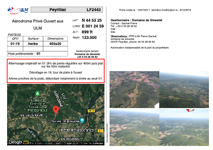
Coordinates: N44°53'25" E1°24'59"
Elevation is 899 feet MSL.
View others Airports in Aquitaine
Operational data
Special qualification required
Current time UTC: 07:12:30
Current local time:
Weather at : LFSL - Brive Souillac ( 17 km )
METAR: LFSL 250700Z AUTO VRB02KT CAVOK 15/12 Q1020 NOSIG
TAF: TAF LFSL 250500Z 2506/2515 16003KT CAVOK
Communications frequencies: [VIEW]
Runways:
| RWY identifier | QFU | Length (ft) | Width (ft) | Surface | LDA (ft) |
| 01 | 0° | 1476 | 65 | GRASS | |
| 19 | 0° | 1476 | 65 | GRASS |
Airport contact information
Address: Peyrillac-et-Millac France
Satellite view of LF2443
Sorry, we have no imagery here.
Sorry, we have no imagery here.
Sorry, we have no imagery here.
Sorry, we have no imagery here.
Sorry, we have no imagery here.
Sorry, we have no imagery here.