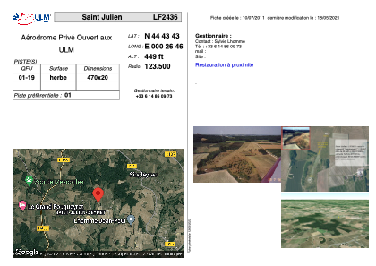
VAC chart of LF2436
 Satellite view of LF2436

Satellite view of LF2436
Sorry, we have no imagery here.
Sorry, we have no imagery here.
Sorry, we have no imagery here.
Sorry, we have no imagery here.
Sorry, we have no imagery here.
Sorry, we have no imagery here.


LF2436 - Saint Julien
Located in Saint-Julien-d'Eymet, France
ICAO - , IATA -
Data provided by AirmateGeneral information
Coordinates: N44°43'43" E0°26'46"
Elevation is 449 feet MSL.
View others Airports in Aquitaine
Operational data
Special qualification required
Current time UTC: 16:11:42
Current local time:
Weather at : LFBE - Bergerac Dordogne Perigord ( 12 km )
METAR: LFBE 251600Z AUTO 28013KT 9999 FEW043 BKN052 BKN110 21/12 Q1020 NOSIG
TAF: TAF LFBE 251100Z 2512/2612 29005KT 9999 BKN030 TEMPO 2517/2521 -SHRA PROB30 TEMPO 2518/2523 BKN010 TEMPO 2604/2607 MIFG
Communications frequencies: [VIEW]
Runways:
| RWY identifier | QFU | Length (ft) | Width (ft) | Surface | LDA (ft) |
| 01 | 0° | 1541 | 65 | GRASS | |
| 19 | 0° | 1541 | 65 | GRASS |
Airport contact information
Address: Saint-Julien-d'Eymet France
Satellite view of LF2436
Sorry, we have no imagery here.
Sorry, we have no imagery here.
Sorry, we have no imagery here.
Sorry, we have no imagery here.
Sorry, we have no imagery here.
Sorry, we have no imagery here.