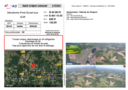
VAC chart of LF2434
 Satellite view of LF2434

Satellite view of LF2434
Sorry, we have no imagery here.
Sorry, we have no imagery here.
Sorry, we have no imagery here.
Sorry, we have no imagery here.
Sorry, we have no imagery here.
Sorry, we have no imagery here.


LF2434 - Saint Crépin Carlucet
Located in Saint-Crépin-et-Carlucet, France
ICAO - , IATA -
Data provided by AirmateGeneral information
Coordinates: N44°58'1" E1°15'3"
Elevation is 840 feet MSL.
View others Airports in Aquitaine
Operational data
Special qualification required
Current time UTC: 10:01:04
Current local time:
Weather at : LFSL - Brive Souillac ( 20 km )
METAR: LFSL 250930Z AUTO 29004KT 230V010 CAVOK 19/10 Q1020 NOSIG
TAF: TAF LFSL 250800Z 2509/2518 28005KT CAVOK TEMPO 2516/2518 BKN040TCU
Communications frequencies: [VIEW]
Runways:
| RWY identifier | QFU | Length (ft) | Width (ft) | Surface | LDA (ft) |
| 06 | 0° | 1640 | 65 | GRASS | |
| 24 | 0° | 1640 | 65 | GRASS |
Airport contact information
Address: Saint-Crépin-et-Carlucet France
