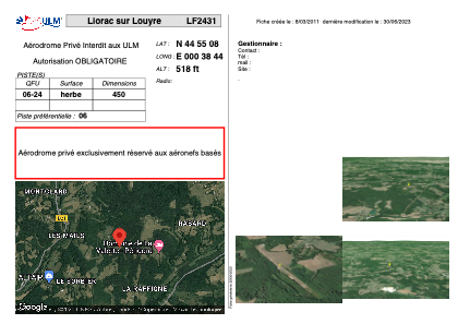
VAC chart of LF2431
 Satellite view of LF2431

Satellite view of LF2431
Sorry, we have no imagery here.
Sorry, we have no imagery here.
Sorry, we have no imagery here.
Sorry, we have no imagery here.
Sorry, we have no imagery here.
Sorry, we have no imagery here.


LF2431 - Liorac sur Louyre
Located in Liorac-sur-Louyre, France
ICAO - , IATA -
Data provided by AirmateGeneral information
Coordinates: N44°55'8" E0°38'44"
Elevation is 518 feet MSL.
View others Airports in Aquitaine
Operational data
Special qualification required
Current time UTC: 00:42:23
Current local time:
Weather at : LFBE - Bergerac Dordogne Perigord ( 14 km )
METAR: LFBE 230030Z AUTO 27004KT CAVOK 10/10 Q1020 BECMG 2000 BR BKN002
TAF: TAF LFBE 222300Z 2300/2324 26005KT CAVOK BECMG 2300/2302 2000 BR BKN002 PROB40 2303/2307 0800 FG VV/// BECMG 2307/2309 CAVOK BECMG 2310/2312 32010KT
Communications frequencies: [VIEW]
Runways:
| RWY identifier | QFU | Length (ft) | Width (ft) | Surface | LDA (ft) |
| 06 | 0° | 1476 | 0 | GRASS | |
| 24 | 0° | 1476 | 0 | GRASS |
Airport contact information
Address: Liorac-sur-Louyre France
Satellite view of LF2431
Sorry, we have no imagery here.
Sorry, we have no imagery here.
Sorry, we have no imagery here.
Sorry, we have no imagery here.
Sorry, we have no imagery here.
Sorry, we have no imagery here.