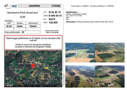
VAC chart of LF2428
 Satellite view of LF2428

Satellite view of LF2428
Sorry, we have no imagery here.
Sorry, we have no imagery here.
Sorry, we have no imagery here.
Sorry, we have no imagery here.
Sorry, we have no imagery here.
Sorry, we have no imagery here.


LF2428 - Javerlhac
Located in Javerlhac-et-la-Chapelle-Saint-Robert, France
ICAO - , IATA -
Data provided by AirmateGeneral information
Coordinates: N45°33'14" E0°33'31"
Elevation is 633 feet MSL.
View others Airports in Poitou-Charentes
Operational data
Special qualification required
Current time UTC: 01:36:28
Current local time:
Weather at : LFBU - Angouleme Brie Champniers ( 33 km )
METAR: LFBU 250130Z AUTO 17002KT CAVOK 11/10 Q1020
TAF: TAF LFBU 241700Z 2418/2518 26010KT CAVOK BECMG 2423/2501 19005KT TEMPO 2510/2514 26010KT -RA TEMPO 2514/2518 3000 -SHRA BKN030TCU PROB30 TEMPO 2516/2518 VRB15G25KT TSRA BKN010 SCT030CB
Communications frequencies: [VIEW]
Runways:
| RWY identifier | QFU | Length (ft) | Width (ft) | Surface | LDA (ft) |
| 05 | 0° | 2395 | 131 | GRASS | |
| 23 | 0° | 2395 | 131 | GRASS |
Airport contact information
Address: Javerlhac-et-la-Chapelle-Saint-Robert France
Satellite view of LF2428
Sorry, we have no imagery here.
Sorry, we have no imagery here.
Sorry, we have no imagery here.
Sorry, we have no imagery here.
Sorry, we have no imagery here.
Sorry, we have no imagery here.