VAC chart of LF2421
 Satellite view of LF2421

Satellite view of LF2421
Sorry, we have no imagery here.
Sorry, we have no imagery here.
Sorry, we have no imagery here.
Sorry, we have no imagery here.
Sorry, we have no imagery here.
Sorry, we have no imagery here.


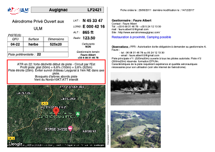
LF2421 - Augignac
Located in Augignac, France
ICAO - , IATA -
Data provided by AirmateGeneral information
Coordinates: N45°33'47" E0°42'16"
Elevation is 865 feet MSL.
View others Airports in Poitou-Charentes
Operational data
Special qualification required
Current time UTC: 21:41:20
Current local time:
Weather at : LFBX - Perigueux Bassillac ( 42 km )
METAR: LFBX 272130Z AUTO 00000KT CAVOK 13/11 Q1024
Communications frequencies: [VIEW]
Runways:
| RWY identifier | QFU | Length (ft) | Width (ft) | Surface | LDA (ft) |
| 04 | 0° | 1722 | 65 | GRASS | |
| 22 | 0° | 1722 | 65 | GRASS |
Airport contact information
Address: Augignac France
Satellite view of LF2421
Sorry, we have no imagery here.
Sorry, we have no imagery here.
Sorry, we have no imagery here.
Sorry, we have no imagery here.
Sorry, we have no imagery here.
Sorry, we have no imagery here.