VAC chart of LF2164
 Satellite view of LF2164

Satellite view of LF2164
Sorry, we have no imagery here.
Sorry, we have no imagery here.
Sorry, we have no imagery here.
Sorry, we have no imagery here.
Sorry, we have no imagery here.
Sorry, we have no imagery here.


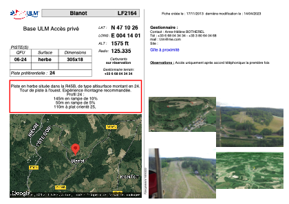
LF2164 - Blanot
Located in Blanot, France
ICAO - , IATA -
Data provided by AirmateGeneral information
Coordinates: N47°10'26" E4°14'1"
Elevation is 1575 feet MSL.
View others Airports in Burgundy
Operational data
Special qualification required
Current time UTC: 21:48:52
Current local time:
Weather at : LFSD - Dijon-Longvic ( 66 km )
METAR: LFSD 212130Z AUTO 28003KT 9999 -RA FEW030/// BKN060/// OVC076/// //////CB 12/11 Q1013
Communications frequencies: [VIEW]
Runways:
| RWY identifier | QFU | Length (ft) | Width (ft) | Surface | LDA (ft) |
| 06 | 0° | 1000 | 59 | GRASS | |
| 24 | 0° | 1000 | 59 | GRASS |
Airport contact information
Address: Blanot France
Satellite view of LF2164
Sorry, we have no imagery here.
Sorry, we have no imagery here.
Sorry, we have no imagery here.
Sorry, we have no imagery here.
Sorry, we have no imagery here.
Sorry, we have no imagery here.