VAC chart of LF2121
 Satellite view of LF2121

Satellite view of LF2121
Sorry, we have no imagery here.
Sorry, we have no imagery here.
Sorry, we have no imagery here.
Sorry, we have no imagery here.
Sorry, we have no imagery here.
Sorry, we have no imagery here.


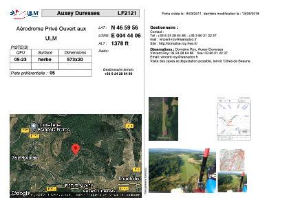
LF2121 - Auxey Duresses
Located in Auxey Duresses, France
ICAO - , IATA -
Data provided by AirmateGeneral information
Coordinates: N46°59'56" E4°44'6"
Elevation is 1378 feet MSL.
View others Airports in Burgundy
Operational data
Special qualification required
Current time UTC: 18:48:50
Current local time:
Weather at : LFSD - Dijon-Longvic ( 40 km )
METAR: LFSD 251830Z AUTO 25008KT CAVOK 18/11 Q1017
Communications frequencies: [VIEW]
Runways:
| RWY identifier | QFU | Length (ft) | Width (ft) | Surface | LDA (ft) |
| 05 | 0° | 1879 | 65 | GRASS | |
| 23 | 0° | 1879 | 65 | GRASS |
Airport contact information
Address: Auxey Duresses France
Satellite view of LF2121
Sorry, we have no imagery here.
Sorry, we have no imagery here.
Sorry, we have no imagery here.
Sorry, we have no imagery here.
Sorry, we have no imagery here.
Sorry, we have no imagery here.