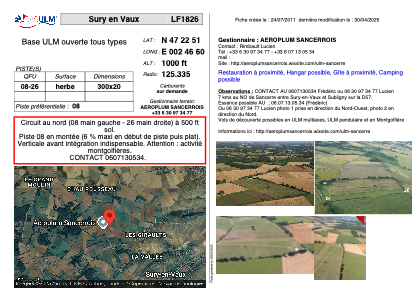
VAC chart of LF1826
 Satellite view of LF1826
Satellite view of LF1826
Sorry, we have no imagery here.
Sorry, we have no imagery here.
Sorry, we have no imagery here.
Sorry, we have no imagery here.
Sorry, we have no imagery here.
Sorry, we have no imagery here.


LF1826 - Sury en Vaux
Located in Sury-en-Vaux, France
ICAO - , IATA -
Data provided by AirmateGeneral information
Coordinates: N47°22'51" E2°46'58"
Elevation is 1000 feet MSL.
View others Airports in Burgundy
Operational data
Special qualification required
Current time UTC: 07:00:37
Current local time:
Weather at : LFOA - Avord ( 38 km )
METAR: LFOA 240630Z AUTO VRB01KT CAVOK 10/06 Q1020
TAF: TAF AMD LFOA 240625Z 2406/2503 VRB02KT CAVOK TX21/2414Z TN09/2406Z
Communications frequencies: [VIEW]
Runways:
| RWY identifier | QFU | Length (ft) | Width (ft) | Surface | LDA (ft) |
| 08 | 0° | 984 | 65 | GRASS | |
| 26 | 0° | 984 | 65 | GRASS |
Airport contact information
Address: Sury-en-Vaux France
Satellite view of LF1826
Sorry, we have no imagery here.
Sorry, we have no imagery here.
Sorry, we have no imagery here.
Sorry, we have no imagery here.
Sorry, we have no imagery here.
Sorry, we have no imagery here.