VAC chart of LF1756
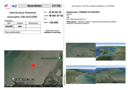 Satellite view of LF1756

Satellite view of LF1756
Sorry, we have no imagery here.
Sorry, we have no imagery here.
Sorry, we have no imagery here.
Sorry, we have no imagery here.
Sorry, we have no imagery here.
Sorry, we have no imagery here.


LF1756 - Bourcefranc
Located in Bourcefranc, France
ICAO - , IATA -
Data provided by AirmateGeneral information
Coordinates: N45°52'19" W1°7'52"
Elevation is feet MSL.
View others Airports in Poitou-Charentes
Operational data
Special qualification required
Current time UTC: 10:43:28
Current local time:
Weather at : LFBH - La Rochelle Ile De Re ( 34 km )
METAR: LFBH 291030Z AUTO 19005KT 140V220 9999 BKN009 OVC014 18/16 Q1025 BECMG NSC
TAF: TAF AMD LFBH 290937Z 2909/3006 VRB04KT 9999 BKN005 OVC011 BECMG 2909/2911 SCT016 BKN020 BECMG 2911/2913 CAVOK
Communications frequencies: [VIEW]
Runways:
Airport contact information
Address: Bourcefranc France
Satellite view of LF1756
Sorry, we have no imagery here.
Sorry, we have no imagery here.
Sorry, we have no imagery here.
Sorry, we have no imagery here.
Sorry, we have no imagery here.
Sorry, we have no imagery here.