VAC chart of LF1727
 Satellite view of LF1727

Satellite view of LF1727
Sorry, we have no imagery here.
Sorry, we have no imagery here.
Sorry, we have no imagery here.
Sorry, we have no imagery here.
Sorry, we have no imagery here.
Sorry, we have no imagery here.


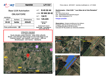
LF1727 - Nantillé
Located in Nantillé, France
ICAO - , IATA -
Data provided by AirmateGeneral information
Coordinates: N45°50'44" W0°28'42"
Elevation is 134 feet MSL.
View others Airports in Poitou-Charentes
Operational data
Special qualification required
Current time UTC: 03:27:12
Current local time:
Weather at : LFBG - Cognac Chateaubernard ( 24 km )
METAR: LFBG 240300Z AUTO 26003KT 5000 0900 R23/1200D BCFG NSC 11/10 Q1021
Communications frequencies: [VIEW]
Runways:
| RWY identifier | QFU | Length (ft) | Width (ft) | Surface | LDA (ft) |
| 04 | 0° | 1312 | 82 | GRASS | |
| 22 | 0° | 1312 | 82 | GRASS |
Airport contact information
Address: Nantillé France
Satellite view of LF1727
Sorry, we have no imagery here.
Sorry, we have no imagery here.
Sorry, we have no imagery here.
Sorry, we have no imagery here.
Sorry, we have no imagery here.
Sorry, we have no imagery here.