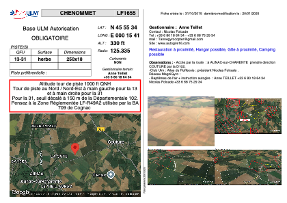
VAC chart of LF1655
 Satellite view of LF1655

Satellite view of LF1655
Sorry, we have no imagery here.
Sorry, we have no imagery here.
Sorry, we have no imagery here.
Sorry, we have no imagery here.
Sorry, we have no imagery here.
Sorry, we have no imagery here.


LF1655 - CHENOMMET
Located in Chenommet/Aunac-sur-Charente, France
ICAO - , IATA -
Data provided by AirmateGeneral information
Coordinates: N45°55'34" E0°15'41"
Elevation is 330 feet MSL.
View others Airports in Poitou-Charentes
Operational data
Special qualification required
Current time UTC: 03:55:00
Current local time:
Weather at : LFBU - Angouleme Brie Champniers ( 22 km )
METAR: LFBU 280330Z AUTO 00000KT 9999 2200 NSC 11/10 Q1024
TAF: TAF LFBU 271700Z 2718/2818 28010KT CAVOK BECMG 2722/2724 VRB03KT TEMPO 2805/2809 BKN007 BECMG 2806/2808 26010KT 9999 SCT020 BECMG 2811/2813 CAVOK
Communications frequencies: [VIEW]
Runways:
| RWY identifier | QFU | Length (ft) | Width (ft) | Surface | LDA (ft) |
| 13 | 0° | 820 | 59 | GRASS | |
| 31 | 0° | 820 | 59 | GRASS |
Airport contact information
Address: Chenommet/Aunac-sur-Charente France
Web: www.autogire16.com
Satellite view of LF1655
Sorry, we have no imagery here.
Sorry, we have no imagery here.
Sorry, we have no imagery here.
Sorry, we have no imagery here.
Sorry, we have no imagery here.
Sorry, we have no imagery here.