VAC chart of LF1654
 Satellite view of LF1654

Satellite view of LF1654
Sorry, we have no imagery here.
Sorry, we have no imagery here.
Sorry, we have no imagery here.
Sorry, we have no imagery here.
Sorry, we have no imagery here.


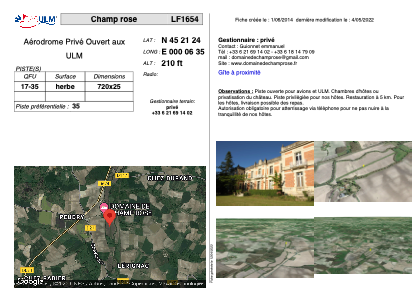
LF1654 - Champ rose
Located in Saint-Laurent-de-Belzagot, France
ICAO - , IATA -
Data provided by AirmateGeneral information
Coordinates: N45°21'24" E0°6'35"
Elevation is 210 feet MSL.
View others Airports in Aquitaine
Operational data
Special qualification required
Current time UTC: 19:41:59
Current local time:
Weather at : LFBU - Angouleme Brie Champniers ( 42 km )
METAR: LFBU 271930Z AUTO 25004KT CAVOK 18/11 Q1024 NOSIG
Communications frequencies: [VIEW]
Runways:
| RWY identifier | QFU | Length (ft) | Width (ft) | Surface | LDA (ft) |
| 17 | 0° | 2362 | 82 | GRASS | |
| 35 | 0° | 2362 | 82 | GRASS |
Airport contact information
Address: Saint-Laurent-de-Belzagot France
Satellite view of LF1654
Sorry, we have no imagery here.
Sorry, we have no imagery here.
Sorry, we have no imagery here.
Sorry, we have no imagery here.
Sorry, we have no imagery here.