VAC chart of LF1653
 Satellite view of LF1653
Satellite view of LF1653
Sorry, we have no imagery here.
Sorry, we have no imagery here.
Sorry, we have no imagery here.
Sorry, we have no imagery here.
Sorry, we have no imagery here.
Sorry, we have no imagery here.


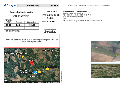
LF1653 - Saint Ciers
Located in Saint-Ciers-sur-Bonnieure, France
ICAO - , IATA -
Data provided by AirmateGeneral information
Coordinates: N45°51'2" E0°15'55"
Elevation is 314 feet MSL.
View others Airports in Poitou-Charentes
Operational data
Special qualification required
Current time UTC: 15:40:33
Current local time:
Weather at : LFBU - Angouleme Brie Champniers ( 14 km )
METAR: LFBU 251530Z AUTO 25013KT 9999 FEW029 BKN037 BKN047 19/13 Q1020 TEMPO 26015G25KT 3000 SHRA BKN020TCU
TAF: TAF LFBU 251100Z 2512/2612 26010KT 9999 BKN025 TEMPO 2514/2519 26015G25KT 3000 SHRA BKN020TCU BECMG 2523/2601 VRB03KT TEMPO 2601/2605 3000 BR BECMG 2607/2609 28005KT
Communications frequencies: [VIEW]
Runways:
| RWY identifier | QFU | Length (ft) | Width (ft) | Surface | LDA (ft) |
| 05 | 0° | 1476 | 98 | GRASS | |
| 23 | 0° | 1476 | 98 | GRASS |
Airport contact information
Address: Saint-Ciers-sur-Bonnieure France
Web: www.rotavia.fr
Satellite view of LF1653
Sorry, we have no imagery here.
Sorry, we have no imagery here.
Sorry, we have no imagery here.
Sorry, we have no imagery here.
Sorry, we have no imagery here.
Sorry, we have no imagery here.