VAC chart of LF1631
 Satellite view of LF1631

Satellite view of LF1631
Sorry, we have no imagery here.
Sorry, we have no imagery here.
Sorry, we have no imagery here.
Sorry, we have no imagery here.
Sorry, we have no imagery here.
Sorry, we have no imagery here.


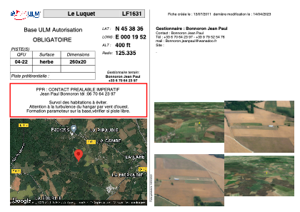
LF1631 - Le Luquet
Located in Chazelles, France
ICAO - , IATA -
Data provided by AirmateGeneral information
Coordinates: N45°38'36" E0°19'52"
Elevation is 400 feet MSL.
View others Airports in Poitou-Charentes
Operational data
Special qualification required
Current time UTC: 14:41:24
Current local time:
Weather at : LFBU - Angouleme Brie Champniers ( 13 km )
METAR: LFBU 241430Z AUTO 26010KT 220V280 CAVOK 22/11 Q1020 NOSIG
TAF: TAF LFBU 241100Z 2412/2512 26010KT CAVOK BECMG 2422/2424 20005KT BECMG 2501/2503 BKN014 PROB30 TEMPO 2505/2508 -RA BECMG 2508/2510 25010KT SCT020 BKN025
Communications frequencies: [VIEW]
Runways:
| RWY identifier | QFU | Length (ft) | Width (ft) | Surface | LDA (ft) |
| 04 | 0° | 853 | 65 | GRASS | |
| 22 | 0° | 853 | 65 | GRASS |
Airport contact information
Address: Chazelles France
Satellite view of LF1631
Sorry, we have no imagery here.
Sorry, we have no imagery here.
Sorry, we have no imagery here.
Sorry, we have no imagery here.
Sorry, we have no imagery here.
Sorry, we have no imagery here.