VAC chart of LF1254
 Satellite view of LF1254

Satellite view of LF1254
Sorry, we have no imagery here.
Sorry, we have no imagery here.
Sorry, we have no imagery here.
Sorry, we have no imagery here.
Sorry, we have no imagery here.
Sorry, we have no imagery here.


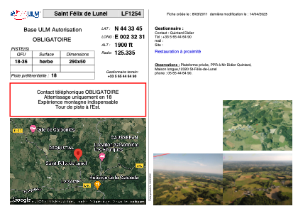
LF1254 - Saint Félix de Lunel
Located in Saint-Félix-de-Lunel, France
ICAO - , IATA -
Data provided by AirmateGeneral information
Coordinates: N44°33'45" E2°32'31"
Elevation is 1900 feet MSL.
View others Airports in Midi-Pyrénées
Operational data
Special qualification required
Current time UTC: 12:40:17
Current local time:
Weather at : LFCR - Rodez Aveyron ( 18 km )
METAR: LFCR 231230Z AUTO 31014KT 9999 FEW045 SCT056 BKN082 17/09 Q1018 TEMPO SCT030TCU
TAF: TAF LFCR 231100Z 2312/2412 31012KT 9999 SCT035 BKN050 TEMPO 2313/2317 SCT030TCU BECMG 2319/2321 CAVOK BECMG 2321/2323 VRB03KT PROB30 TEMPO 2402/2406 3000 BR BECMG 2409/2411 30010KT BKN040
Communications frequencies: [VIEW]
Runways:
| RWY identifier | QFU | Length (ft) | Width (ft) | Surface | LDA (ft) |
| 18 | 0° | 951 | 164 | GRASS | |
| 36 | 0° | 951 | 164 | GRASS |
Airport contact information
Address: Saint-Félix-de-Lunel France
Satellite view of LF1254
Sorry, we have no imagery here.
Sorry, we have no imagery here.
Sorry, we have no imagery here.
Sorry, we have no imagery here.
Sorry, we have no imagery here.
Sorry, we have no imagery here.