ADC chart of L92
 Satellite view of L92

Satellite view of L92
Sorry, we have no imagery here.
Sorry, we have no imagery here.
Sorry, we have no imagery here.
Sorry, we have no imagery here.
Sorry, we have no imagery here.
Sorry, we have no imagery here.


L92 - Alamo Landing Fld
Located in Alamo, United States
ICAO - L92, IATA -
Data provided by AirmateGeneral information
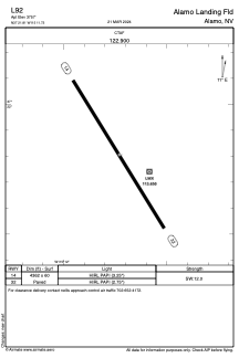
Coordinates: N37°21'48" W115°11'44"
Elevation is 3757 feet MSL.
Magnetic variation is 14° East View others Airports in Nevada
Operational data
Special qualification required
Current time UTC: 21:38:06
Current local time:
Weather at : - ( 0 km )
METAR: KY19 232135Z AUTO 11010G16KT 10SM FEW070 BKN110 19/07 A3005 RMK AO2
Communications frequencies: [VIEW]
Runways:
| RWY identifier | QFU | Length (ft) | Width (ft) | Surface | LDA (ft) |
| 14 | 148° | 4362 | 60 | ASPH | |
| 32 | 328° | 4362 | 60 | ASPH |
Airport contact information
Address: Alamo United States
Satellite view of L92
Sorry, we have no imagery here.
Sorry, we have no imagery here.
Sorry, we have no imagery here.
Sorry, we have no imagery here.
Sorry, we have no imagery here.
Sorry, we have no imagery here.