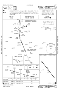
IAC chart of KVBW
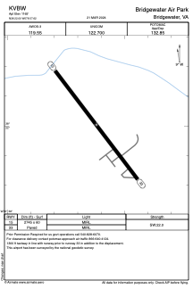
 ADC chart of KVBW
 Satellite view of KVBW
ADC chart of KVBW
Satellite view of KVBW
Sorry, we have no imagery here.
Sorry, we have no imagery here.
Sorry, we have no imagery here.
Sorry, we have no imagery here.
Sorry, we have no imagery here.
Sorry, we have no imagery here.


KVBW - Bridgewater Air Park
Located in Bridgewater, United States
ICAO - VBW, IATA -
Data provided by AirmateGeneral information
Coordinates: N38°21'55" W78°57'32"
Elevation is 1165 feet MSL.
Magnetic variation is -09° East View others Airports in Virginia
Operational data
Special qualification required
Current time UTC: 03:54:34
Current local time:
Weather
METAR: KVBW 230335Z AUTO 26004KT 10SM SCT049 SCT110 11/08 A2988 RMK AO1 T01130076
Communications frequencies: [VIEW]
Runways:
| RWY identifier | QFU | Length (ft) | Width (ft) | Surface | LDA (ft) |
| 15 | 143° | 4034 | 60 | ASPH | |
| 33 | 323° | 4034 | 60 | ASPH |
Airport contact information
Address: Bridgewater United States
Satellite view of KVBW
Sorry, we have no imagery here.
Sorry, we have no imagery here.
Sorry, we have no imagery here.
Sorry, we have no imagery here.
Sorry, we have no imagery here.
Sorry, we have no imagery here.