ADC chart of KUIL
 Satellite view of KUIL

Satellite view of KUIL
Sorry, we have no imagery here.
Sorry, we have no imagery here.
Sorry, we have no imagery here.
Sorry, we have no imagery here.
Sorry, we have no imagery here.


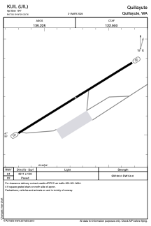
KUIL - Quillayute
Located in Quillayute, United States
ICAO - UIL, IATA -
Data provided by AirmateGeneral information
Coordinates: N47°56'12" W124°33'45"
Elevation is 194 feet MSL.
Magnetic variation is 21° East View others Airports in Washington
Operational data
Special qualification required
Current time UTC: 16:46:58
Current local time:
Weather
METAR: KUIL 251553Z AUTO 10SM OVC049 13/09 A2999 RMK AO2 SLP156 T01330094
Communications frequencies: [VIEW]
Runways:
| RWY identifier | QFU | Length (ft) | Width (ft) | Surface | LDA (ft) |
| 04 | 58° | 4211 | 100 | CONC | |
| 22 | 238° | 4211 | 100 | CONC |
Airport contact information
Address: Quillayute United States
Satellite view of KUIL
Sorry, we have no imagery here.
Sorry, we have no imagery here.
Sorry, we have no imagery here.
Sorry, we have no imagery here.
Sorry, we have no imagery here.