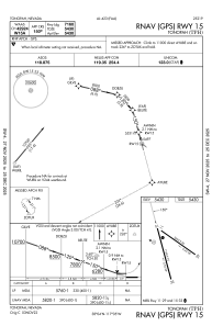
IAC chart of KTPH
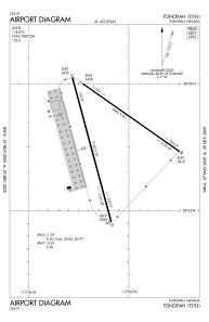
 ADC chart of KTPH
 Satellite view of KTPH

ADC chart of KTPH
Satellite view of KTPH
Sorry, we have no imagery here.
Sorry, we have no imagery here.
Sorry, we have no imagery here.
Sorry, we have no imagery here.
Sorry, we have no imagery here.
Sorry, we have no imagery here.


KTPH - Tonopah
Located in Tonopah, United States
ICAO - TPH, IATA -
Data provided by AirmateGeneral information
Coordinates: N38°3'36" W117°5'12"
Elevation is 5430 feet MSL.
Magnetic variation is 15° East View others Airports in Nevada
Operational data
Special qualification required
Current time UTC: 21:37:42
Current local time:
Weather
METAR: KTPH 192056Z AUTO 30017G26KT 10SM CLR 21/M05 A3014 RMK AO2 PK WND 28034/2039 SLP162 T02061050 58006
TAF: KTPH 191720Z 1918/2018 34025G35KT P6SM SKC FM200400 36011KT P6SM SKC FM201700 29008G18KT P6SM SKC
Communications frequencies: [VIEW]
Runways:
| RWY identifier | QFU | Length (ft) | Width (ft) | Surface | LDA (ft) |
| 11 | 125° | 5660 | 50 | ASPH | |
| 29 | 305° | 5660 | 50 | ASPH | |
| 15 | 165° | 7160 | 75 | ASPH | |
| 33 | 345° | 7160 | 75 | ASPH | |
| H1 | 0° | 0 | 0 | UNK |
Airport contact information
Address: Tonopah United States
Satellite view of KTPH
Sorry, we have no imagery here.
Sorry, we have no imagery here.
Sorry, we have no imagery here.
Sorry, we have no imagery here.
Sorry, we have no imagery here.
Sorry, we have no imagery here.