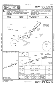
IAC chart of KSPZ
 Satellite view of KSPZ

Satellite view of KSPZ
Sorry, we have no imagery here.
Sorry, we have no imagery here.
Sorry, we have no imagery here.
Sorry, we have no imagery here.
Sorry, we have no imagery here.
Sorry, we have no imagery here.


KSPZ - Silver Springs
Located in Silver Springs, United States
ICAO - SPZ, IATA -
Data provided by AirmateGeneral information
Coordinates: N39°24'11" W119°15'4"
Elevation is 4265 feet MSL.
Magnetic variation is 13° East View others Airports in Nevada
Operational data
Special qualification required
Current time UTC: 18:37:42
Current local time:
Weather at : KRNO - Reno/Tahoe Intl ( 46 km )
METAR: KRNO 221818Z 26013G24KT 10SM CLR 23/M12 A2999 RMK AO2 WSHFT 1803 T02331122
TAF: KRNO 221720Z 2218/2318 23016G26KT P6SM SKC WS020/24015KT FM221900 24024G34KT P6SM FEW100 FEW200 WS020/24015KT FM230300 28011KT P6SM SCT200 FM230600 29005KT P6SM SCT200
Communications frequencies: [VIEW]
Runways:
| RWY identifier | QFU | Length (ft) | Width (ft) | Surface | LDA (ft) |
| 06 | 0° | 6001 | 75 | ASPH | |
| 24 | 0° | 6001 | 75 | ASPH |
Airport contact information
Address: Silver Springs United States
Satellite view of KSPZ
Sorry, we have no imagery here.
Sorry, we have no imagery here.
Sorry, we have no imagery here.
Sorry, we have no imagery here.
Sorry, we have no imagery here.
Sorry, we have no imagery here.