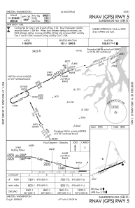
IAC chart of KSHN
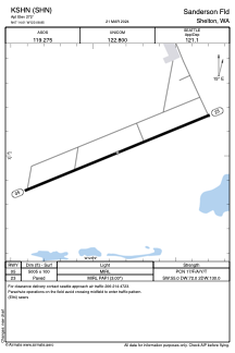
 ADC chart of KSHN
 Satellite view of KSHN

ADC chart of KSHN
Satellite view of KSHN
Sorry, we have no imagery here.
Sorry, we have no imagery here.
Sorry, we have no imagery here.
Sorry, we have no imagery here.
Sorry, we have no imagery here.
Sorry, we have no imagery here.


KSHN - Sanderson Fld
Located in Shelton, United States
ICAO - SHN, IATA -
Data provided by AirmateGeneral information
Coordinates: N47°14'1" W123°8'51"
Elevation is 272 feet MSL.
Magnetic variation is 15° East View others Airports in Washington
Operational data
Special qualification required
Current time UTC: 18:29:58
Current local time:
Weather
METAR: KSHN 301753Z AUTO 00000KT 10SM CLR 18/08 A3021 RMK AO2 SLP230 T01780083 10183 20033 58007
Communications frequencies: [VIEW]
Runways:
| RWY identifier | QFU | Length (ft) | Width (ft) | Surface | LDA (ft) |
| 05 | 68° | 5005 | 100 | ASPH | |
| 23 | 248° | 5005 | 100 | ASPH |
Airport contact information
Address: Shelton United States
