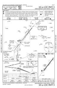
IAC chart of KSHD
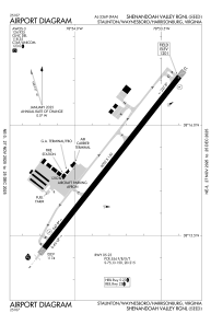
 ADC chart of KSHD
 Satellite view of KSHD

ADC chart of KSHD
Satellite view of KSHD
Sorry, we have no imagery here.
Sorry, we have no imagery here.
Sorry, we have no imagery here.
Sorry, we have no imagery here.
Sorry, we have no imagery here.
Sorry, we have no imagery here.


KSHD - Shenandoah Valley Rgnl
Located in Staunton/Waynesboro/Harrisonburg, United States
ICAO - SHD, IATA - SHD
Data provided by AirmateGeneral information
Coordinates: N38°15'50" W78°53'47"
Elevation is 1201 feet MSL.
Magnetic variation is -09° East View others Airports in Virginia
Operational data
Special qualification required
Current time UTC: 17:21:40
Current local time:
Weather
METAR: KSHD 301715Z AUTO 24006KT 7SM SCT043 BKN048 BKN070 23/14 A2971 RMK AO2 T02250141
Communications frequencies: [VIEW]
Runways:
| RWY identifier | QFU | Length (ft) | Width (ft) | Surface | LDA (ft) |
| 05 | 38° | 6002 | 150 | ASPH | 6002 |
| 23 | 218° | 6002 | 150 | ASPH | 6002 |
Airport contact information
Address: Staunton/Waynesboro/Harrisonburg United States
