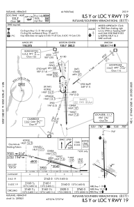
IAC chart of KRUT
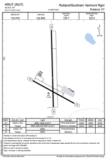
 ADC chart of KRUT
 Satellite view of KRUT
ADC chart of KRUT
Satellite view of KRUT
Sorry, we have no imagery here.
Sorry, we have no imagery here.
Sorry, we have no imagery here.
Sorry, we have no imagery here.
Sorry, we have no imagery here.
Sorry, we have no imagery here.


KRUT - Rutland/Southern Vermont Rgnl
Located in Rutland, United States
ICAO - RUT, IATA - RUT
Data provided by AirmateGeneral information
Coordinates: N43°31'47" W72°56'59"
Elevation is 787 feet MSL.
Magnetic variation is -15° East View others Airports in Vermont
Operational data
Special qualification required
Current time UTC: 06:49:59
Current local time:
Weather
METAR: KRUT 280556Z AUTO 14007KT 10SM CLR 11/08 A3028 RMK AO2 SLP248 T01110078 10200 20111 51001 $
TAF: KRUT 280520Z 2806/2906 13006KT P6SM BKN210 FM281200 00000KT P6SM FEW210
Communications frequencies: [VIEW]
Runways:
| RWY identifier | QFU | Length (ft) | Width (ft) | Surface | LDA (ft) |
| 01 | 359° | 5304 | 100 | ASPH | 5004 |
| 19 | 179° | 5304 | 100 | ASPH | 5004 |
| 13 | 119° | 3169 | 75 | ASPH | |
| 31 | 299° | 3169 | 75 | ASPH |
Airport contact information
Address: Rutland United States
Satellite view of KRUT
Sorry, we have no imagery here.
Sorry, we have no imagery here.
Sorry, we have no imagery here.
Sorry, we have no imagery here.
Sorry, we have no imagery here.
Sorry, we have no imagery here.