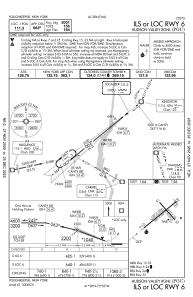
IAC chart of KPOU
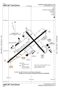
 ADC chart of KPOU
 Satellite view of KPOU

ADC chart of KPOU
Satellite view of KPOU
Sorry, we have no imagery here.
Sorry, we have no imagery here.
Sorry, we have no imagery here.
Sorry, we have no imagery here.
Sorry, we have no imagery here.
Sorry, we have no imagery here.


KPOU - Hudson Valley Rgnl
Located in Poughkeepsie, United States
ICAO - POU, IATA - POU
Data provided by AirmateGeneral information
Coordinates: N41°37'36" W73°53'3"
Elevation is 163 feet MSL.
Magnetic variation is -12° East View others Airports in New York
Operational data
Special qualification required
Current time UTC: 02:13:34
Current local time:
Weather
METAR: KPOU 230153Z 00000KT 10SM OVC055 08/06 A2983 RMK AO2 RAE08 SLP099 P0001 T00830061
TAF: KPOU 222357Z 2300/2324 03006KT P6SM -RA SCT015 OVC060 TEMPO 2300/2302 4SM -RA BR BKN025 OVC050 FM230400 36003KT P6SM BKN015 OVC025 FM231300 VRB03KT 6SM -RA BR SCT008 OVC012 FM231900 24005KT P6SM BKN025 OVC040 FM232200 26008KT P6SM BKN040
Communications frequencies: [VIEW]
Runways:
| RWY identifier | QFU | Length (ft) | Width (ft) | Surface | LDA (ft) |
| 06 | 51° | 5001 | 100 | ASPH | 5001 |
| 24 | 231° | 5001 | 100 | ASPH | 4886 |
| 07 | 51° | 1357 | 100 | GRASS | |
| 25 | 231° | 1357 | 100 | GRASS | |
| 15 | 139° | 2743 | 100 | OTHER | 2743 |
| 33 | 319° | 2743 | 100 | OTHER | 2743 |
Airport contact information
Address: Poughkeepsie United States
Satellite view of KPOU
Sorry, we have no imagery here.
Sorry, we have no imagery here.
Sorry, we have no imagery here.
Sorry, we have no imagery here.
Sorry, we have no imagery here.
Sorry, we have no imagery here.