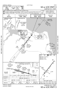
IAC chart of KORF
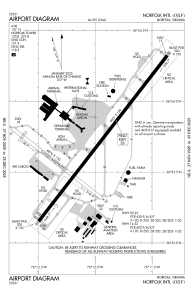
 ADC chart of KORF
 Satellite view of KORF

ADC chart of KORF
Satellite view of KORF
Sorry, we have no imagery here.
Sorry, we have no imagery here.
Sorry, we have no imagery here.
Sorry, we have no imagery here.
Sorry, we have no imagery here.
Sorry, we have no imagery here.


KORF - Norfolk Intl
Located in Norfolk, United States
ICAO - ORF, IATA - ORF
Data provided by AirmateGeneral information
Coordinates: N36°53'41" W76°12'4"
Elevation is 26 feet MSL.
Magnetic variation is -09° East View others Airports in Virginia
Operational data
Special qualification required
Current time UTC: 02:36:05
Current local time:
Weather
METAR: KORF 290151Z VRB03KT 10SM OVC017 20/18 A3005 RMK AO2 SLP176 T02000178
TAF: KORF 290125Z 2901/2924 VRB04KT P6SM BKN015 FM290500 VRB04KT 4SM BR OVC007 FM291100 30005KT P6SM BKN015 FM291500 VRB05KT P6SM BKN040
Communications frequencies: [VIEW]
Runways:
| RWY identifier | QFU | Length (ft) | Width (ft) | Surface | LDA (ft) |
| 05 | 38° | 9001 | 150 | OTHER | 7809 |
| 23 | 218° | 9001 | 150 | OTHER | 8995 |
| 14 | 128° | 4876 | 150 | ASPH | 4301 |
| 32 | 308° | 4876 | 150 | ASPH | 3901 |
Airport contact information
Address: Norfolk United States
Satellite view of KORF
Sorry, we have no imagery here.
Sorry, we have no imagery here.
Sorry, we have no imagery here.
Sorry, we have no imagery here.
Sorry, we have no imagery here.
Sorry, we have no imagery here.