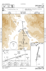
IAC chart of KOMK
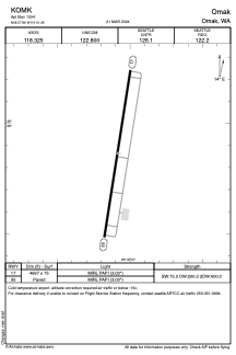
 ADC chart of KOMK
 Satellite view of KOMK

ADC chart of KOMK
Satellite view of KOMK
Sorry, we have no imagery here.
Sorry, we have no imagery here.
Sorry, we have no imagery here.
Sorry, we have no imagery here.
Sorry, we have no imagery here.
Sorry, we have no imagery here.


KOMK - Omak
Located in Omak, United States
ICAO - OMK, IATA - OMK
Data provided by AirmateGeneral information
Coordinates: N48°27'52" W119°31'5"
Elevation is 1304 feet MSL.
Magnetic variation is 16° East View others Airports in Washington
Operational data
Special qualification required
Current time UTC: 22:52:23
Current local time:
Weather
METAR: KOMK 302153Z AUTO 21009KT 10SM CLR 27/04 A3018 RMK AO2 SLP217 T02720044
Communications frequencies: [VIEW]
Runways:
| RWY identifier | QFU | Length (ft) | Width (ft) | Surface | LDA (ft) |
| 17 | 189° | 4667 | 75 | ASPH | |
| 35 | 9° | 4667 | 75 | ASPH |
Airport contact information
Address: Omak United States
Satellite view of KOMK
Sorry, we have no imagery here.
Sorry, we have no imagery here.
Sorry, we have no imagery here.
Sorry, we have no imagery here.
Sorry, we have no imagery here.
Sorry, we have no imagery here.