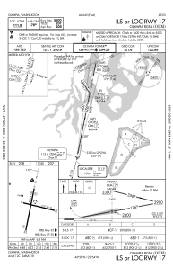
IAC chart of KOLM
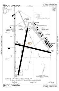
 ADC chart of KOLM
 Satellite view of KOLM

ADC chart of KOLM
Satellite view of KOLM
Sorry, we have no imagery here.
Sorry, we have no imagery here.
Sorry, we have no imagery here.
Sorry, we have no imagery here.
Sorry, we have no imagery here.
Sorry, we have no imagery here.


KOLM - Olympia Rgnl
Located in Olympia, United States
ICAO - OLM, IATA - OLM
Data provided by AirmateGeneral information
Coordinates: N46°58'10" W122°54'9"
Elevation is 207 feet MSL.
Magnetic variation is 15° East View others Airports in Washington
Operational data
Special qualification required
Current time UTC: 10:08:31
Current local time:
Weather
METAR: KOLM 290954Z AUTO 20003KT 10SM OVC024 13/10 A3004 RMK AO2 SLP172 T01280100
TAF: KOLM 290909Z 2909/3006 17005KT P6SM OVC025 FM291100 21005KT P6SM -RA OVC020 FM291500 21009KT P6SM OVC015 FM292000 27010KT P6SM SKC FM300500 VRB03KT P6SM SKC
Communications frequencies: [VIEW]
Runways:
| RWY identifier | QFU | Length (ft) | Width (ft) | Surface | LDA (ft) |
| 08 | 104° | 4157 | 150 | ASPH | |
| 26 | 284° | 4157 | 150 | ASPH | |
| 17 | 191° | 5500 | 150 | ASPH | |
| 35 | 11° | 5500 | 150 | ASPH |
Airport contact information
Address: Olympia United States
