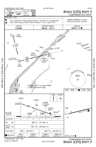
IAC chart of KOGS
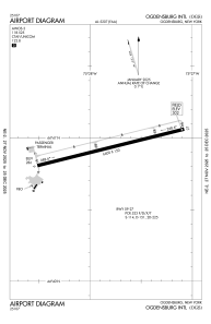
 ADC chart of KOGS
 Satellite view of KOGS
ADC chart of KOGS
Satellite view of KOGS
Sorry, we have no imagery here.
Sorry, we have no imagery here.
Sorry, we have no imagery here.
Sorry, we have no imagery here.
Sorry, we have no imagery here.
Sorry, we have no imagery here.


KOGS - Ogdensburg Intl
Located in Ogdensburg, United States
ICAO - OGS, IATA - OGS
Data provided by AirmateGeneral information
Coordinates: N44°40'56" W75°27'48"
Elevation is 301 feet MSL.
Magnetic variation is -13° East View others Airports in New York
Operational data
Special qualification required
Current time UTC: 22:44:24
Current local time:
Weather
METAR: KOGS 282235Z AUTO VRB06KT 10SM FEW080 26/09 A3008 RMK AO2
Communications frequencies: [VIEW]
Runways:
| RWY identifier | QFU | Length (ft) | Width (ft) | Surface | LDA (ft) |
| 09 | 76° | 6400 | 150 | ASPH | 6006 |
| 27 | 256° | 6400 | 150 | ASPH | 6035 |
Airport contact information
Address: Ogdensburg United States
Satellite view of KOGS
Sorry, we have no imagery here.
Sorry, we have no imagery here.
Sorry, we have no imagery here.
Sorry, we have no imagery here.
Sorry, we have no imagery here.
Sorry, we have no imagery here.