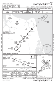
IAC chart of KNTU
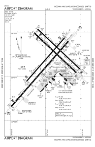
 ADC chart of KNTU
 Satellite view of KNTU

ADC chart of KNTU
Satellite view of KNTU
Sorry, we have no imagery here.
Sorry, we have no imagery here.
Sorry, we have no imagery here.
Sorry, we have no imagery here.
Sorry, we have no imagery here.
Sorry, we have no imagery here.


KNTU - Oceana Nas (Apollo Soucek Fld)
Located in Virginia Beach, United States
ICAO - NTU, IATA -
Data provided by AirmateGeneral information
Coordinates: N36°49'22" W76°1'55"
Elevation is 22 feet MSL.
Magnetic variation is -10° East View others Airports in Virginia
Operational data
Special qualification required
Current time UTC: 19:35:19
Current local time:
Weather
METAR: KNTU 281856Z 17006KT 6SM -RA BR BKN005 OVC017 22/21 A3003 RMK AO2 SLP170 P0005 T02170206
TAF: TAF KNTU 2815/2915 14012KT 8000 -SHRA BKN015 OVC025 540009 QNH2998INS TEMPO 2815/2819 16015G25KT 3200 SHRA BR BKN005 OVC015 FM281900 15012KT 9999 BKN010 OVC025 500000 QNH2993INS TEMPO 2819/2901 VRB20G35KT 3200 TSRA BR BKN005CB OVC015 FM290100 23010KT 9999 BKN025 OVC050 QNH2995INS TEMPO 2901/2907 8000 -SHRA BKN015 OVC025 FM290900 VRB06KT 9999 BKN015 OVC030 TX24/2819Z TN17/2909Z FN20008
Communications frequencies: [VIEW]
Runways:
| RWY identifier | QFU | Length (ft) | Width (ft) | Surface | LDA (ft) |
| 05L | 42° | 8000 | 150 | OTHER | |
| 23R | 222° | 8000 | 150 | OTHER | |
| 05R | 42° | 12001 | 200 | OTHER | |
| 23L | 222° | 12001 | 200 | OTHER | |
| 14L | 134° | 8001 | 150 | OTHER | |
| 32R | 314° | 8001 | 150 | OTHER | |
| 14R | 134° | 8000 | 200 | OTHER | |
| 32L | 314° | 8000 | 200 | OTHER |
Airport contact information
Address: Virginia Beach United States