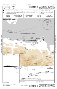
IAC chart of KNOW
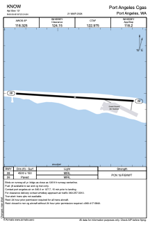
 ADC chart of KNOW
 Satellite view of KNOW

ADC chart of KNOW
Satellite view of KNOW
Sorry, we have no imagery here.
Sorry, we have no imagery here.
Sorry, we have no imagery here.
Sorry, we have no imagery here.
Sorry, we have no imagery here.
Sorry, we have no imagery here.


KNOW - Port Angeles Cgas
Located in Port Angeles, United States
ICAO - NOW, IATA -
Data provided by AirmateGeneral information
Coordinates: N48°8'29" W123°24'50"
Elevation is 13 feet MSL.
Magnetic variation is 17° East View others Airports in Washington
Operational data
Special qualification required
Current time UTC: 07:12:32
Current local time:
Weather
METAR: KNOW 250650Z AUTO 27010G14KT 10SM CLR 11/08 A2997 RMK AO2 T01090080 401560077
Communications frequencies: [VIEW]
Runways:
| RWY identifier | QFU | Length (ft) | Width (ft) | Surface | LDA (ft) |
| 08 | 93° | 4500 | 150 | ASPH | |
| 26 | 273° | 4500 | 150 | ASPH |
Airport contact information
Address: Port Angeles United States
Satellite view of KNOW
Sorry, we have no imagery here.
Sorry, we have no imagery here.
Sorry, we have no imagery here.
Sorry, we have no imagery here.
Sorry, we have no imagery here.
Sorry, we have no imagery here.