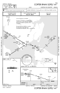
IAC chart of KNHU
 Satellite view of KNHU

Satellite view of KNHU
Sorry, we have no imagery here.
Sorry, we have no imagery here.
Sorry, we have no imagery here.
Sorry, we have no imagery here.
Sorry, we have no imagery here.
Sorry, we have no imagery here.


KNHU - Norfolk Ns
Located in Norfolk, United States
ICAO - NHU, IATA -
Data provided by AirmateGeneral information
Coordinates: N36°57'20" W76°18'14"
Elevation is 10 feet MSL.
Magnetic variation is -10° East View others Airports in Virginia
Operational data
Special qualification required
Current time UTC: 00:54:46
Current local time:
Weather at : KNGU - Norfolk Ns (Chambers Fld) ( 2 km )
TAF: TAF KNGU 2723/2823 09012KT 8000 -SHRA SCT012 BKN035 OVC090 QNH3015INS TEMPO 2801/2806 4800 SHRA BKN012 OVC090 FM280600 12012KT 8000 RA BKN012 OVC030 QNH3009INS TEMPO 2806/2812 14012G20KT 3200 RA BR BKN008 OVC030 FM281200 14015G23KT 8000 RA VCTS BKN020CB BKN090 OVC250 QNH2997INS TEMPO 2812/2818 VRB20G35KT 3200 TSRA BKN012CB OVC030 TX22/2820Z TN14/2809Z FN20079
Communications frequencies: [VIEW]
Runways:
| RWY identifier | QFU | Length (ft) | Width (ft) | Surface | LDA (ft) |
| 09 | 86° | 1705 | 150 | ASPH | |
| 27 | 266° | 1705 | 150 | ASPH | |
| H1 | 0° | 0 | 0 | UNK | |
| H2 | 0° | 0 | 0 | UNK | |
| H3 | 0° | 0 | 0 | UNK | |
| H4 | 0° | 0 | 0 | UNK | |
| H5 | 0° | 0 | 0 | UNK | |
| H6 | 0° | 0 | 0 | UNK | |
| H7 | 0° | 0 | 0 | UNK | |
| H8 | 0° | 0 | 0 | UNK | |
| H9 | 0° | 0 | 0 | UNK |
Airport contact information
Address: Norfolk United States