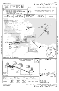
IAC chart of KNGU
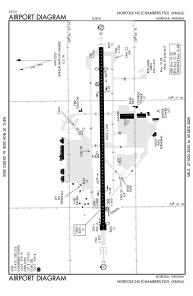
 ADC chart of KNGU
 Satellite view of KNGU

ADC chart of KNGU
Satellite view of KNGU
Sorry, we have no imagery here.
Sorry, we have no imagery here.
Sorry, we have no imagery here.
Sorry, we have no imagery here.
Sorry, we have no imagery here.
Sorry, we have no imagery here.


KNGU - Norfolk Ns (Chambers Fld)
Located in Norfolk, United States
ICAO - NGU, IATA -
Data provided by AirmateGeneral information
Coordinates: N36°56'15" W76°17'21"
Elevation is 14 feet MSL.
Magnetic variation is -10° East View others Airports in Virginia
Operational data
Special qualification required
Current time UTC: 11:48:17
Current local time:
Weather
METAR: KNGU 301115Z 00000KT 6SM BR BKN009 OVC013 20/19 A2982 RMK AO2 CIG 006V011 T02000194
TAF: TAF KNGU 3007/3107 24009KT 9999 VCSH SCT010 BKN035 OVC100 641008 QNH2965INS TEMPO 3008/3014 4800 SHRA BR BKN008 OVC025 BECMG 3014/3016 22009KT 9999 NSW SCT030 BKN140 600000 QNH2952INS FM302000 24009G18KT 9999 VCTS SCT025CB BKN080 BKN200 QNH2948INS TEMPO 3020/3101 VRB15G30KT 3200 TSRA BKN025CB OVC060 BECMG 3102/3104 28020G28KT 9999 NSW FEW030 SCT100 QNH2949INS TX26/3020Z TN20/3010Z FN00287
Communications frequencies: [VIEW]
Runways:
| RWY identifier | QFU | Length (ft) | Width (ft) | Surface | LDA (ft) |
| 10 | 90° | 8370 | 200 | ASPH | 8071 |
| 28 | 270° | 8370 | 200 | ASPH | 7375 |
Airport contact information
Address: Norfolk United States
Satellite view of KNGU
Sorry, we have no imagery here.
Sorry, we have no imagery here.
Sorry, we have no imagery here.
Sorry, we have no imagery here.
Sorry, we have no imagery here.
Sorry, we have no imagery here.