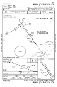
IAC chart of KNFL
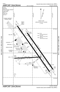
 ADC chart of KNFL
 Satellite view of KNFL

ADC chart of KNFL
Satellite view of KNFL
Sorry, we have no imagery here.
Sorry, we have no imagery here.
Sorry, we have no imagery here.
Sorry, we have no imagery here.
Sorry, we have no imagery here.
Sorry, we have no imagery here.


KNFL - Fallon Nas (Van Voorhis Fld)
Located in Fallon, United States
ICAO - NFL, IATA -
Data provided by AirmateGeneral information
Coordinates: N39°25'4" W118°41'55"
Elevation is 3934 feet MSL.
Magnetic variation is 14° East View others Airports in Nevada
Operational data
Special qualification required
Current time UTC: 00:54:45
Current local time:
Weather
METAR: KNFL 272357Z 00000KT 10SM SCT080 SCT240 32/M05 A2995 RMK AO2 SLP116 T03171050 10322 20244 56023
TAF: KNFL TAF 2723/2823 26006KT 9999 SCT080 SCT240 QNH2988INS TEMPO 2800/2804 28010G18KT FM280500 VRB06KT 9999 SKC QNH2996INS FM281800 VRB06KT 9999 FEW080 QNH2985INS AUTOMATED SENSOR METWATCH 2806 TIL 2814 TX32/2723Z TN11/2813Z FS30198
Communications frequencies: [VIEW]
Runways:
| RWY identifier | QFU | Length (ft) | Width (ft) | Surface | LDA (ft) |
| 07 | 88° | 7003 | 152 | ASPH | |
| 25 | 268° | 7003 | 152 | ASPH | |
| 13L | 145° | 11076 | 200 | CONC | |
| 31R | 325° | 11076 | 200 | CONC | |
| 13R | 145° | 14001 | 201 | ASPH | |
| 31L | 325° | 14001 | 201 | ASPH |
Airport contact information
Address: Fallon United States
Satellite view of KNFL
Sorry, we have no imagery here.
Sorry, we have no imagery here.
Sorry, we have no imagery here.
Sorry, we have no imagery here.
Sorry, we have no imagery here.
Sorry, we have no imagery here.