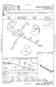
IAC chart of KMTV
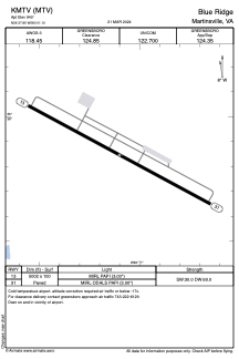
 ADC chart of KMTV
 Satellite view of KMTV

ADC chart of KMTV
Satellite view of KMTV
Sorry, we have no imagery here.
Sorry, we have no imagery here.
Sorry, we have no imagery here.
Sorry, we have no imagery here.
Sorry, we have no imagery here.
Sorry, we have no imagery here.


KMTV - Blue Ridge
Located in Martinsville, United States
ICAO - MTV, IATA -
Data provided by AirmateGeneral information
Coordinates: N36°37'51" W80°1'6"
Elevation is 940 feet MSL.
Magnetic variation is -07° East View others Airports in Virginia
Operational data
Special qualification required
Current time UTC: 20:43:03
Current local time:
Weather
METAR: KMTV 302035Z AUTO 22011G16KT 10SM SCT030 SCT055 BKN090 22/16 A2965 RMK AO2 T02170164
Communications frequencies: [VIEW]
Runways:
| RWY identifier | QFU | Length (ft) | Width (ft) | Surface | LDA (ft) |
| 13 | 118° | 5002 | 100 | ASPH | |
| 31 | 298° | 5002 | 100 | ASPH |
Airport contact information
Address: Martinsville United States
Satellite view of KMTV
Sorry, we have no imagery here.
Sorry, we have no imagery here.
Sorry, we have no imagery here.
Sorry, we have no imagery here.
Sorry, we have no imagery here.
Sorry, we have no imagery here.