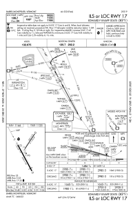
IAC chart of KMPV
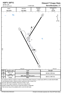
 ADC chart of KMPV
 Satellite view of KMPV

ADC chart of KMPV
Satellite view of KMPV
Sorry, we have no imagery here.
Sorry, we have no imagery here.
Sorry, we have no imagery here.
Sorry, we have no imagery here.
Sorry, we have no imagery here.
Sorry, we have no imagery here.


KMPV - Edward F Knapp State
Located in Barre/Montpelier, United States
ICAO - MPV, IATA - MPV
Data provided by AirmateGeneral information
Coordinates: N44°12'13" W72°33'44"
Elevation is 1165 feet MSL.
Magnetic variation is -16° East View others Airports in Vermont
Operational data
Special qualification required
Current time UTC: 01:13:16
Current local time:
Weather
METAR: KMPV 260051Z AUTO 29004KT 10SM FEW050 OVC070 11/07 A3011 RMK AO2 SLP202 T01110067
TAF: KMPV 252331Z 2600/2624 VRB03KT P6SM BKN120 PROB30 2600/2602 6SM -SHRA FM260300 VRB03KT P6SM OVC035 FM261200 VRB03KT P6SM SCT040 BKN100
Communications frequencies: [VIEW]
Runways:
| RWY identifier | QFU | Length (ft) | Width (ft) | Surface | LDA (ft) |
| 05 | 32° | 3001 | 75 | ASPH | |
| 23 | 212° | 3001 | 75 | ASPH | |
| 17 | 152° | 5000 | 100 | ASPH | |
| 35 | 332° | 5000 | 100 | ASPH |
Airport contact information
Address: Barre/Montpelier United States
