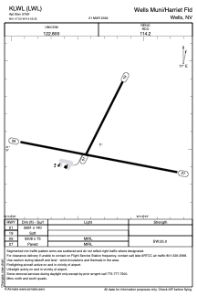
ADC chart of KLWL
 Satellite view of KLWL

Satellite view of KLWL
Sorry, we have no imagery here.
Sorry, we have no imagery here.
Sorry, we have no imagery here.
Sorry, we have no imagery here.
Sorry, we have no imagery here.
Sorry, we have no imagery here.


KLWL - Wells Muni/Harriet Fld
Located in Wells, United States
ICAO - LWL, IATA - LWL
Data provided by AirmateGeneral information
Coordinates: N41°7'2" W114°55'20"
Elevation is 5769 feet MSL.
Magnetic variation is 17° East View others Airports in Nevada
Operational data
Special qualification required
Current time UTC: 21:06:01
Current local time:
Weather at : KEKO - Elko Rgnl ( 80 km )
METAR: KEKO 272056Z AUTO 34006KT 10SM FEW100 28/M03 A3010 RMK AO2 SLP148 T02781033 58016
TAF: KEKO 271720Z 2718/2818 05007KT P6SM FEW250 FM272000 22009KT P6SM BKN120 FM280100 05008KT P6SM SCT120
Communications frequencies: [VIEW]
Runways:
| RWY identifier | QFU | Length (ft) | Width (ft) | Surface | LDA (ft) |
| 01 | 27° | 2681 | 140 | OTHER | |
| 19 | 207° | 2681 | 140 | OTHER | |
| 09 | 101° | 5508 | 75 | ASPH | |
| 27 | 281° | 5508 | 75 | ASPH |
Airport contact information
Address: Wells United States
Satellite view of KLWL
Sorry, we have no imagery here.
Sorry, we have no imagery here.
Sorry, we have no imagery here.
Sorry, we have no imagery here.
Sorry, we have no imagery here.
Sorry, we have no imagery here.