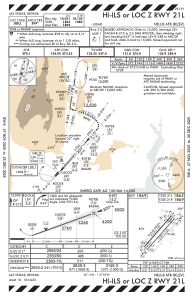
IAC chart of KLSV
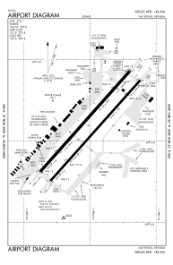
 ADC chart of KLSV
 Satellite view of KLSV

ADC chart of KLSV
Satellite view of KLSV
Sorry, we have no imagery here.
Sorry, we have no imagery here.
Sorry, we have no imagery here.
Sorry, we have no imagery here.
Sorry, we have no imagery here.
Sorry, we have no imagery here.


KLSV - Nellis Afb
Located in Las Vegas, United States
ICAO - LSV, IATA - LSV
Data provided by AirmateGeneral information
Coordinates: N36°14'10" W115°2'3"
Elevation is 1869 feet MSL.
Magnetic variation is 12° East View others Airports in Nevada
Operational data
Special qualification required
Current time UTC: 04:26:43
Current local time:
Weather
METAR: KLSV 280355Z 19009KT 10SM BKN180 33/M11 A2981 RMK AO2A SLP065 T03321115 $
Communications frequencies: [VIEW]
Runways:
| RWY identifier | QFU | Length (ft) | Width (ft) | Surface | LDA (ft) |
| 03L | 41° | 10120 | 200 | CONC | |
| 21R | 221° | 10120 | 200 | CONC | |
| 03R | 41° | 10051 | 150 | CONC | |
| 21L | 221° | 10051 | 150 | CONC | |
| H1 | 0° | 0 | 0 | UNK |
Airport contact information
Address: Las Vegas United States
Satellite view of KLSV
Sorry, we have no imagery here.
Sorry, we have no imagery here.
Sorry, we have no imagery here.
Sorry, we have no imagery here.
Sorry, we have no imagery here.
Sorry, we have no imagery here.