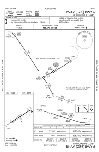
IAC chart of KLNP
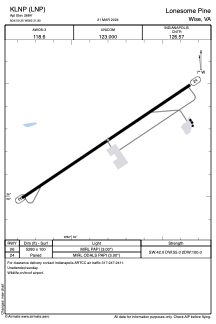
 ADC chart of KLNP
 Satellite view of KLNP

ADC chart of KLNP
Satellite view of KLNP
Sorry, we have no imagery here.
Sorry, we have no imagery here.
Sorry, we have no imagery here.
Sorry, we have no imagery here.
Sorry, we have no imagery here.
Sorry, we have no imagery here.


KLNP - Lonesome Pine
Located in Wise, United States
ICAO - LNP, IATA - LNP
Data provided by AirmateGeneral information
Coordinates: N36°59'15" W82°31'47"
Elevation is 2684 feet MSL.
Magnetic variation is -06° East View others Airports in Virginia
Operational data
Special qualification required
Current time UTC: 01:13:14
Current local time:
Weather
METAR: KLNP 260055Z AUTO 01005KT 10SM DZ OVC042 13/07 A3021 RMK AO2
Communications frequencies: [VIEW]
Runways:
| RWY identifier | QFU | Length (ft) | Width (ft) | Surface | LDA (ft) |
| 06 | 56° | 5131 | 100 | ASPH | |
| 24 | 236° | 5131 | 100 | ASPH |
Airport contact information
Address: Wise United States
Satellite view of KLNP
Sorry, we have no imagery here.
Sorry, we have no imagery here.
Sorry, we have no imagery here.
Sorry, we have no imagery here.
Sorry, we have no imagery here.
Sorry, we have no imagery here.