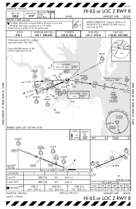
IAC chart of KLFI
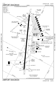
 ADC chart of KLFI
 Satellite view of KLFI
ADC chart of KLFI
Satellite view of KLFI
Sorry, we have no imagery here.
Sorry, we have no imagery here.
Sorry, we have no imagery here.
Sorry, we have no imagery here.
Sorry, we have no imagery here.
Sorry, we have no imagery here.


KLFI - Langley Afb
Located in Hampton, United States
ICAO - LFI, IATA - LFI
Data provided by AirmateGeneral information
Coordinates: N37°4'58" W76°21'38"
Elevation is 8 feet MSL.
Magnetic variation is -10° East View others Airports in Virginia
Operational data
Special qualification required
Current time UTC: 13:23:50
Current local time:
Weather
METAR: KLFI 301310Z 26009KT 10SM SCT009 OVC014 22/20 A2978 RMK AO2A CIG 009V014 CIG 012 RWY08 SLP091 $
TAF: TAF AMD KLFI 301216Z 3012/3115 23009KT 9999 SCT010 BKN035 QNH2981INS TEMPO 3012/3015 BKN009 BECMG 3020/3021 23012G20KT 6000 -SHRA SCT030 BKN050 QNH2974INS TEMPO 3021/3103 25020G35KT 3600 TSRA BKN020CB BECMG 3103/3104 27015G25KT 9999 NSW SCT030 BKN055 QNH2970INS TX26/3020Z TN21/3012Z
Communications frequencies: [VIEW]
Runways:
| RWY identifier | QFU | Length (ft) | Width (ft) | Surface | LDA (ft) |
| 08 | 0° | 10002 | 150 | CONC | |
| 26 | 0° | 10002 | 150 | CONC |
Airport contact information
Address: Hampton United States
Satellite view of KLFI
Sorry, we have no imagery here.
Sorry, we have no imagery here.
Sorry, we have no imagery here.
Sorry, we have no imagery here.
Sorry, we have no imagery here.
Sorry, we have no imagery here.