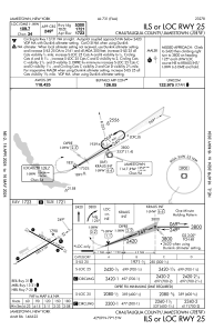
IAC chart of KJHW
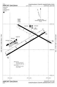
 ADC chart of KJHW
 Satellite view of KJHW

ADC chart of KJHW
Satellite view of KJHW
Sorry, we have no imagery here.
Sorry, we have no imagery here.
Sorry, we have no imagery here.
Sorry, we have no imagery here.
Sorry, we have no imagery here.
Sorry, we have no imagery here.


KJHW - Chautauqua County/Jamestown
Located in Jamestown, United States
ICAO - JHW, IATA - JHW
Data provided by AirmateGeneral information
Coordinates: N42°9'12" W79°15'29"
Elevation is 1723 feet MSL.
Magnetic variation is -10° East View others Airports in New York
Operational data
Special qualification required
Current time UTC: 02:25:05
Current local time:
Weather
METAR: KJHW 210156Z AUTO 08010KT 10SM CLR 12/04 A2991 RMK AO2 SLP137 T01170044 PNO $
TAF: KJHW 202339Z 2100/2124 06007KT P6SM SKC FM210700 11009KT P6SM -RA OVC070 FM210900 11010KT 4SM RA OVC030 FM211200 11012G19KT 4SM RA OVC007 FM211800 15015G22KT 5SM -RA BR OVC012 PROB30 2120/2123 2SM -TSRA OVC008CB FM212300 14012G19KT 4SM -RA OVC007 PROB30 2123/2124 2SM TSRA OVC006CB
Communications frequencies: [VIEW]
Runways:
| RWY identifier | QFU | Length (ft) | Width (ft) | Surface | LDA (ft) |
| 07 | 59° | 5300 | 100 | ASPH | 5300 |
| 25 | 239° | 5300 | 100 | ASPH | 5300 |
| 13 | 119° | 4499 | 100 | ASPH | 4499 |
| 31 | 299° | 4499 | 100 | ASPH | 4499 |
Airport contact information
Address: Jamestown United States
Other aviation service providers
Flight schools

Jamestown Aviation Company, Llc
Jamestown Aviation Company, Llc
lnalbone@jamestownaviation.com+1(716)665-4800