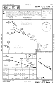
IAC chart of KIUA
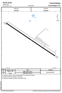
 ADC chart of KIUA
 Satellite view of KIUA

ADC chart of KIUA
Satellite view of KIUA
Sorry, we have no imagery here.
Sorry, we have no imagery here.
Sorry, we have no imagery here.
Sorry, we have no imagery here.
Sorry, we have no imagery here.
Sorry, we have no imagery here.


KIUA - Canandaigua
Located in Canandaigua, United States
ICAO - IUA, IATA -
Data provided by AirmateGeneral information
Coordinates: N42°54'32" W77°19'31"
Elevation is 813 feet MSL.
Magnetic variation is -12° East View others Airports in New York
Operational data
Special qualification required
Current time UTC: 17:42:12
Current local time:
Weather at : KROC - Frederick Douglass/Greater Rochester Intl ( 37 km )
METAR: KROC 281654Z 16011G19KT 10SM FEW055 SCT110 OVC140 17/08 A3021 RMK AO2 SLP233 T01720078
TAF: KROC 281735Z 2818/2918 15012G25KT P6SM -RA BKN060 FM282100 12008KT 5SM -RA OVC030 FM290300 13007KT 4SM -RA OVC012 FM291100 17005KT 6SM BR OVC020 PROB30 2911/2915 4SM -SHRA OVC015 FM291500 24007KT P6SM BKN020
Communications frequencies: [VIEW]
Runways:
| RWY identifier | QFU | Length (ft) | Width (ft) | Surface | LDA (ft) |
| 13 | 123° | 5500 | 100 | ASPH | |
| 31 | 303° | 5500 | 100 | ASPH |
Airport contact information
Address: Canandaigua United States
Satellite view of KIUA
Sorry, we have no imagery here.
Sorry, we have no imagery here.
Sorry, we have no imagery here.
Sorry, we have no imagery here.
Sorry, we have no imagery here.
Sorry, we have no imagery here.