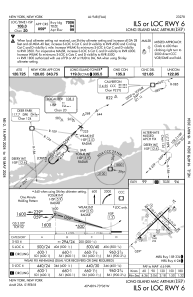
IAC chart of KISP
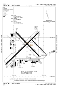
 ADC chart of KISP
 Satellite view of KISP

ADC chart of KISP
Satellite view of KISP
Sorry, we have no imagery here.
Sorry, we have no imagery here.
Sorry, we have no imagery here.
Sorry, we have no imagery here.
Sorry, we have no imagery here.
Sorry, we have no imagery here.


KISP - Long Island Mac Arthur
Located in New York, United States
ICAO - ISP, IATA - ISP
Data provided by AirmateGeneral information
Coordinates: N40°47'46" W73°6'2"
Elevation is 98 feet MSL.
Magnetic variation is -14° East View others Airports in New York
Operational data
Special qualification required
Current time UTC: 13:36:38
Current local time:
Weather
METAR: KISP 231256Z VRB04KT 10SM SCT016 OVC025 11/07 A2979 RMK AO2 SLP089 T01110067
TAF: KISP 231204Z 2312/2412 26004KT P6SM SCT015 BKN025 TEMPO 2313/2315 BKN015 FM231500 27005KT P6SM BKN015 FM231800 26010G16KT P6SM VCSH BKN025 FM232000 28010G16KT P6SM VCSH SCT025 BKN040 FM240000 29008KT P6SM SCT040 BKN080 FM241000 28012KT P6SM SCT080
Communications frequencies: [VIEW]
Runways:
| RWY identifier | QFU | Length (ft) | Width (ft) | Surface | LDA (ft) |
| 06 | 45° | 7006 | 150 | ASPH | 7006 |
| 24 | 225° | 7006 | 150 | ASPH | 7006 |
| 15L | 135° | 3175 | 75 | ASPH | 3175 |
| 33R | 315° | 3175 | 75 | ASPH | 3175 |
| 15R | 135° | 5186 | 150 | ASPH | 5186 |
| 33L | 315° | 5186 | 150 | ASPH | 5186 |
| H1 | 0° | 0 | 0 | UNK | |
| H2 | 0° | 0 | 0 | UNK |
Airport contact information
Address: New York United States
Other aviation service providers
Flight schools

Helicopter Flight Training, Inc.
Helicopter Flight Training, Inc.
easternhelicopte@aol.com+1(631)467-2232
Heritage Flight Academy, Llc
Heritage Flight Academy, Llc
info@heritageflightacademy.com+1(631)471-3550
Atp Flight School (800-All-Atps)
Atp Flight School (800-All-Atps)
info@atpflightschool.com+1(800)255-2877