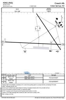
ADC chart of KINS
 Satellite view of KINS

Satellite view of KINS
Sorry, we have no imagery here.
Sorry, we have no imagery here.
Sorry, we have no imagery here.
Sorry, we have no imagery here.
Sorry, we have no imagery here.
Sorry, we have no imagery here.


KINS - Creech Afb
Located in Indian Springs, United States
ICAO - INS, IATA - INS
Data provided by AirmateGeneral information
Coordinates: N36°35'11" W115°40'39"
Elevation is 3134 feet MSL.
Magnetic variation is 15° East View others Airports in Nevada
Operational data
Special qualification required
Current time UTC: 00:19:41
Current local time:
Weather
METAR: KINS 242355Z AUTO 25006G22KT 10SM FEW150 31/M15 A2981 RMK AO2 SLP041 T03141155 10320 20266 56009 $
Communications frequencies: [VIEW]
Runways:
| RWY identifier | QFU | Length (ft) | Width (ft) | Surface | LDA (ft) |
| 08 | 93° | 9002 | 150 | ASPH | |
| 26 | 273° | 9002 | 150 | ASPH | |
| 13 | 0° | 5476 | 100 | ASPH | |
| 31 | 0° | 5476 | 100 | ASPH |
Airport contact information
Address: Indian Springs United States
Satellite view of KINS
Sorry, we have no imagery here.
Sorry, we have no imagery here.
Sorry, we have no imagery here.
Sorry, we have no imagery here.
Sorry, we have no imagery here.
Sorry, we have no imagery here.