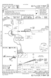
IAC chart of KIAG
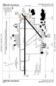
 ADC chart of KIAG
 Satellite view of KIAG

ADC chart of KIAG
Satellite view of KIAG
Sorry, we have no imagery here.
Sorry, we have no imagery here.
Sorry, we have no imagery here.
Sorry, we have no imagery here.
Sorry, we have no imagery here.
Sorry, we have no imagery here.


KIAG - Niagara Falls Intl
Located in Niagara Falls, United States
ICAO - IAG, IATA - IAG
Data provided by AirmateGeneral information
Coordinates: N43°6'27" W78°56'45"
Elevation is 592 feet MSL.
Magnetic variation is -10° East View others Airports in New York
Operational data
Special qualification required
Current time UTC: 21:47:33
Current local time:
Weather
METAR: KIAG 292053Z 24013G23KT 10SM BKN060 21/11 A2990 RMK AO2 SLP125 T02060111 58019
TAF: KIAG 291849Z 2919/3018 24013G25KT P6SM VCSH BKN020 TEMPO 2919/2921 P6SM SCT020 BKN050 FM292100 23013G21KT P6SM OVC050 FM300000 22009KT P6SM SCT050 FM300500 25006KT P6SM SCT050 FM300800 22007KT P6SM BKN060 FM301300 23008KT P6SM SCT100
Communications frequencies: [VIEW]
Runways:
| RWY identifier | QFU | Length (ft) | Width (ft) | Surface | LDA (ft) |
| 06 | 50° | 5188 | 150 | ASPH | 5188 |
| 24 | 230° | 5188 | 150 | ASPH | 5108 |
| 10L | 90° | 9826 | 150 | OTHER | 9129 |
| 28R | 270° | 9826 | 150 | OTHER | 9129 |
| 10R | 90° | 3972 | 78 | ASPH | 3973 |
| 28L | 270° | 3972 | 78 | ASPH | 3973 |
Airport contact information
Address: Niagara Falls United States
