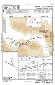
IAC chart of KHTH
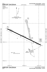
 ADC chart of KHTH
 Satellite view of KHTH

ADC chart of KHTH
Satellite view of KHTH
Sorry, we have no imagery here.
Sorry, we have no imagery here.
Sorry, we have no imagery here.
Sorry, we have no imagery here.
Sorry, we have no imagery here.
Sorry, we have no imagery here.


KHTH - Hawthorne Industrial
Located in Hawthorne, United States
ICAO - HTH, IATA -
Data provided by AirmateGeneral information
Coordinates: N38°32'42" W118°37'57"
Elevation is 4230 feet MSL.
Magnetic variation is 13° East View others Airports in Nevada
Operational data
Special qualification required
Current time UTC: 05:31:52
Current local time:
Weather
METAR: KHTH 290515Z AUTO 01010KT 10SM CLR 25/02 A2997 RMK A01
Communications frequencies: [VIEW]
Runways:
| RWY identifier | QFU | Length (ft) | Width (ft) | Surface | LDA (ft) |
| 10 | 0° | 6000 | 100 | ASPH | |
| 28 | 0° | 6000 | 100 | ASPH | |
| 15 | 0° | 3250 | 130 | EARTH | |
| 33 | 0° | 3250 | 130 | EARTH |
Airport contact information
Address: Hawthorne United States
Satellite view of KHTH
Sorry, we have no imagery here.
Sorry, we have no imagery here.
Sorry, we have no imagery here.
Sorry, we have no imagery here.
Sorry, we have no imagery here.
Sorry, we have no imagery here.