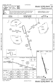
IAC chart of KHTF
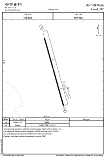
 ADC chart of KHTF
 Satellite view of KHTF

ADC chart of KHTF
Satellite view of KHTF
Sorry, we have no imagery here.
Sorry, we have no imagery here.
Sorry, we have no imagery here.
Sorry, we have no imagery here.
Sorry, we have no imagery here.
Sorry, we have no imagery here.


KHTF - Hornell Muni
Located in Hornell, United States
ICAO - HTF, IATA -
Data provided by AirmateGeneral information
Coordinates: N42°22'56" W77°40'56"
Elevation is 1219 feet MSL.
Magnetic variation is -11° East View others Airports in New York
Operational data
Special qualification required
Current time UTC: 21:36:06
Current local time:
Weather at : KDSV - Dansville Muni ( 21 km )
METAR: KDSV 242054Z AUTO 29011G19KT 240V320 10SM FEW030 BKN049 OVC060 14/06 A3005 RMK AO2 SLP187 60000 T01390061 51006
Communications frequencies: [VIEW]
Runways:
| RWY identifier | QFU | Length (ft) | Width (ft) | Surface | LDA (ft) |
| 18 | 164° | 5000 | 75 | ASPH | |
| 36 | 344° | 5000 | 75 | ASPH |
Airport contact information
Address: Hornell United States
Satellite view of KHTF
Sorry, we have no imagery here.
Sorry, we have no imagery here.
Sorry, we have no imagery here.
Sorry, we have no imagery here.
Sorry, we have no imagery here.
Sorry, we have no imagery here.